
Peopling the Past brings you an ongoing blog series, “Unknown Peoples”, featuring researchers who investigate understudied and/or marginalized peoples in the past.
I’m Daniel Calderbank, an archaeologist and ceramicist who has spent the last eight years researching Mesopotamian states of the Middle-Late Bronze Age. I have worked on projects in southern Iraq and Iraqi-Kurdistan as excavator and ceramicist, with my research focusing mainly on the poorly understood centuries of the mid-second millennium BCE.

What/where was the sealand?
After about two hundred years of organised archaeological and Assyriological research in the region, it’s tempting to assume that the basic framework of Mesopotamian political history is now deeply etched into our respective disciplines. Our accounts of the Middle-Late Bronze Age, for instance, are dominated by the partially entwined fates of two major political powers: the Old Babylonian Dynasty (ca. 1790-1595 BCE) and the Kassite Dynasty (ca. 1600-1150 BCE). Yet the centuries spanning the gradual disintegration of the Old Babylonian state and the emergence of Kassite power remain some of the least understood in Mesopotamian history. It was a time of apparently major textual and settlement rupture, which is evocatively referred to as a ‘Dark Age’.
Snippets of historical evidence provide only a faded silhouette of what occurred during this so-called ‘Dark Age.’ Babylonian King lists of the first millennium BCE make reference to a mysterious dynasty of the “kings of Urukug,” with the Chronicle of Ancient Kings suggesting that it emerged as a rebellious secessionist state, engaging in an ongoing power tussle with various Late Old Babylonian rulers between 1720-1595 BCE, before finally being ousted by the expansionist Kassites in about 1475 BCE.
In the same chronicle, Urukug is connected with the important toponym of the “Sealand,” a region commonly identified with the southernmost reaches of Iraq, where unique marshlands from where the Euphrates and Tigris rivers meet close to the Gulf. This wetland territory was the setting for a number of important ancient cities, such as Ur, Uruk, Larsa, and Lagash, all of which are presumed to have been largely abandoned as a consequence of the upheavals of the mid-second millennium BCE. Only Nippur, in central Babylonia, has provided any positive evidence for early Sealand presence, yielding a handful of tablets inscribed with the date formula of the first Sealand king, Iluma-ilu (ca. 1720 BCE).

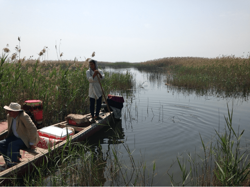
We do not know the full territorial reach of the Sealand. Whether or not Sealand control ever stretched any further north than Nippur has been a topic of debate based on circumstantial evidence; however, administrative douments from Bahrain (ancient Dilmun) strongly suggest that their influence did extend much further southwards, across the Gulf littoral zone. This would no doubt have allowed the Sealanders to tap into the lucrative maritime trade routes to the east.
Transformative Discoveries
Our traditional sources tell us exceedingly little about the inner workings of Sealand state and society, or indeed its material basis. However, recent chance discoveries coupled with scientific excavation has proven transformative.
The first of these surfaced in 2009, with S. Dalley’s publication of about 500 cuneiform tablets from the private Schøyen collection. These tablets could be associated directly with the first Sealand Dynasty, and more specifically to a couple of decades spanning the reigns of its seventh and eighth kings, Pešgaldaramaš and Ayadaragalama. The archive was the product of palatial administration, with texts accounting for the movement of beer and animal carcasses, preparations for ritual performances, dedications to various deities, and even meals prepared for the king’s table. Unfortunately, the tablets are of unknown provenance, thus drastically limiting their interpretive potential. A remarkable, yet controversial discovery.
It was only with excavations at Tell Khaiber, located approximately 20km northwest of Ur, that Sealand period texts and materials were found in situ for the first time. Between 2013 and 2017, a team led by the Ur Region Archaeology Project and the University of Manchester exposed the architectural plan of an enormous 84 x 53m mudbrick building. The building has a thick outer perimeter wall, punctuated on all sides by hollow projecting towers, and has just one entranceway on its northwest face. A long central corridor links the northern two-thirds of the building with a separate southern unit, while two parallel corridors lead to rooms on the eastern and western wings. The northern unit has a series of standardised rooms, probably residential spaces, as well as areas for beer brewing, and rooms for communal eating and drinking, while the southern unit has a central courtyard, a kitchen, a long reception room, and a collection of rooms in the southeast corner that housed the cuneiform tablet archive.


This archive of approximately 150 in situ tablets, studied by E. Robson, is comprised largely of tabular accounts dealing with the circulation of barley, but also contains ephemeral notes, personal letters, and numerical accounts tallying the receipt of certain goods (e.g. pottery vessels). Date formulae on some of these tablets date the building to the reign of Sealand king Ayadaragalama (ca. mid-late 16th century BCE), and locate Tell Khaiber within the broader economic network of an unnamed “palace.”

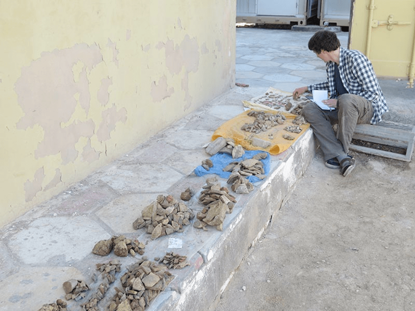
Tell Khaiber has also provided the full repertoire of Mesopotamian material culture: figurines, iconographic plaques, metal tools, children’s toys, and (most importantly) pots! I recorded 150,000 sherds, 10,000 diagnostic sherds, and about 400 complete or nearly complete vessels. Through their appearance is plain and humble, this assemblage has proved enormously informative in a number of ways. While the main shapes remain very similar to those of the Old Babylonian period (which might, in part, explain their lack of identification before now), it has been possible to recognise a collection of subtle diagnostic features unique to the Sealand period. And these diagnostic features now provide the basis for identifying traces of Sealand occupation from past and future survey/excavation in the wider region. For example, extensive paralells exist between the Tell Khaiber assemblage and excavated assemblages from the Gulf, at Failaka Island and Qala’at al-Bahrain, particularly amongst vessels used for eating and drinking. These everyday commensal practices may well have served to bind the dispersed communities of the Sealand, helping to forge deep rooted cultural connections across the Gulf littoral zone.
Further Reading
Boivin, O. 2018. The First Dynasty of the Sealand in Mesopotamia. Boston: De Gruyter.
Calderbank, D. 2020. Dispersed Communities of Practice During the First Dynasty of the Sealand: The Pottery from Tell Khaiber, Southern Iraq. In Paulus, S., and Clayden, T. (eds.) Babylonia Under the Sealand and Kassite Dynasties (SANER 24). Berlin: De Gruyter, 57–86.
Calderbank, D. 2021. Pottery from Tell Khaiber: A Craft Tradition of the First Sealand Dynasty (Archaeology of Ancient Iraq 1). Ludlow: Moonrise Press Ltd.
Dalley, S. 2009. Babylonian Tablets from the First Sealand Dynasty in the Schøyen Collection. Bethesda, MD: CDL Press.
Moon, J. (ed.). forthcoming. Tell Khaiber: A Fortified Outpost of the First Sealand Dynasty (Archaeology of Ancient Iraq 2). Ludlow: Moonrise Press Ltd.
Dr. Calderbank is a British Academy Postdoctoral Research Fellow in the Archaeology of the Ancient Near East at the University of Glasgow. His special interest is in the everyday crafts of ancient Mesopotamia: the manufacture, use and discard of objects, and the complex ways that these activities articulated both with situated social practices, and with the long-term processes of early state formation.
